Downtown Circulation Plan
Downtown Circulation Plan
The City of Ann Arbor is considering a new Downtown Circulation Plan. This plan will be a comprehensive look at how people move around downtown, and how we can make that movement more efficient, safe, and sustainable. Here are a set of ideas that could be included in that plan if we want to make downtown a more pedestrian friendly place, meet our climate goals, tackle affordadable housing, and make the city more equitable.
It should also be noted that these plans attempt to follow the City's existing plans, goals, and priorities. The City has already adopted a Climate Action Plan, a Vision Zero Plan, and a Downtown Plan. These ideas are meant to build on those plans and help the City achieve its goals.
context
Most of the plans and ideas on this site will start with a bit of context. This is important because it helps outline the goals and priorities of the plan so we can agree on what we're trying to accomplish. The specific goals and priorities may change over time, but the context will help us understand why we're doing what we're doing.
General Ann Arbor context
I encourage you to read another article on this site that covers the overall context of Ann Arbor as a city in Michigan near Detroit. One that must cater to the University of Michigan, a large research institution, and the surrounding community. Click here to read that article.
[article coming soon]
Downtown context
Downtown Ann Arbor is a vibrant place. It's the heart of the city, and it's where people come to work, shop, eat, and play. It's also where more and more people live, and where many come to visit for huge events such as Michigan Football games and the Art Fair. It's a place that's full of energy, and it's a place that's full of life.
THe goal of Downtown Ann Arbor, and most downtown areas, is to be a vibrant hub where commerce, culture, and community come together. In order to achieve this, it must promote a variety of people to participate in the events, shopping, and living in the area. This creates a vibrant and diverse community that is welcoming to all.
The problem with relying almost entirely on cars for transportation into and around downtown is that it creates a barrier to entry for many people. Cars are expensive to own and operate, and they take up a lot of space. This means that people who can't afford cars, or who choose not to own them or are unable or unwilling to drive, are at a disadvantage when it comes to safely accessing downtown and other areas.
In order to do this, we must have a balanced approachh to mobility in downtown. This means that we need to make it easier and safer for people to walk, bike, and take public transit, and drive into and around downtown. It also means that we need to make it easier and more affordable for people to live and work in downtown without relying on cars. Not everyone driving to downtown "needs" to or even wants to drive, but they feel they have no other option because taking the bus is too long, or their isn't a good bike lane to their destination, or they can't afford to live in the downtown area itself and must drive in from the suburbs. For those who have no interest in driving, they are paying a cost in terms of owning a car, insurance, gas, and parking that they don't want to pay.
Why Balance is Key
The reason balance is the primary goal is that it's the most equitable way to move people around. Not everyone can afford a car, or wants to own one. Not everyone can walk or bike to their destination. Not everyone can take public transit. But if we have a balanced approach to mobility, we can make it easier for everyone to get where they need to go. It also allows for flexibility in the case where one or more modes become defficult or impossible to use.
For example, imagine a city that is entirely dependent on cars for transportation. If there's a major accident on the highway, or a gas shortage, or just simply construction being done on an important road, the city could experieince siginficant traffic. This creates economic limitations, drives additional emissions from idling vehicles, makes people waste more of their time in traffic in their vehicle, and mroe. But if a city has a balanced approach to mobility, people can still get where they need to go even if one mode of transportation is unavailable. Don't want to wait in traffic for 40 minutes to get across town because the main road you use is under construction? Take the bus, bike, or walk. Cold day and don't want to talk or bike? Take the bus or even drive. Not every trip needs to be driven in a car, and not every trip needs to be taken on foot.
KPIs
In 2021 the City published a Mobility Study which, among other things, outlined the current mode share of trips within Ann Arbor. So note, that is not people driving in from outside of town, or leaving town. These are trips that start and end within the city.
For those trips, the mode share is as follows:
- ~65%% Single Occupancy Vehicle
- 16% Walking
- 11% Biking
- 9% Transit
Key Performance Indicators are a way to measure the success of a plan. Here are some KPIs that could be used to measure the success of the Downtown Circulation Plan:
- Increase in the number of people walking, biking, and taking public transit into and around downtown
- Decrease in the number of people driving into and around downtown
- The goal should be a balance of modes, not a complete elimination of cars
- Something closer to a 25% SOV mode share, 25% walking, 25% biking, and 25% transit would be a good goal to aim for.
- For context here are some other cities mode shares:
Ideas for the Downtown Circulation Plan
In general, the plans and ideas below for the Downtown Circulation Plan are meant to help the City achieve its goals of reducing emissions, increasing safety, and promoting equity. They are also meant to help the City achieve its goals of promoting a vibrant downtown that is accessible to all.
Specifically, the ideas are meant to help the City achieve the following goals:
- Create transit priority roads and intersections that allow our public transit vehicles to move through downtown quickly and reliably, regardless of the traffic conditions.
- Create a network of protected bike lanes that allow people to bike safely and comfortably into and around downtown.
- Create year-round pedestrian priority areas and streets that allow people to walk safely and comfortably into and around downtown.
- Apply pedestrian daylighting to all intersections in downtown to increase visibility and safety for people walking.
- Update significant portions of the street parking to prioritize other uses accommodate more handicap parking, bike parking, loading zones, and more.
- Ensure private vehicles have multiple options to park in downtown especially in parking garages, but that parking is not the primary use of the street.
These ideas are meant to be a starting point for the City as it develops its Downtown Circulation Plan. They are meant to be a way to get people thinking about what a more sustainable, safe, and equitable downtown could look like. They are also meant to be a way to get people thinking about how they can help the City achieve its goals of reducing emissions, increasing safety, and promoting equity.
Downtown Circulation Plan Ideas Overview Map
This is a map card component.
Legend
- Transit-Priority Streets
- Pedestrian Priority Streets
- Parking Lot or Garage
- Bus routes into transit streets
- Vehicle routes to Parking Lots or Garages
- Road Reconfigurations
Transit Priority Roads and Intersections
Transit priority roads and intersections are roads and intersections that are designed to allow our public transit vehicles to move through downtown quickly and reliably, regardless of the traffic conditions. These roads and intersections are designed to give public transit vehicles the right of way, and to allow them to move through downtown without getting stuck in traffic. This helps to make public transit a more attractive option for people who are looking to get into and around downtown.
Ever tried to get the bus home from work or during a busy time and it takes forever or the bus is way late? Transit priority roads and intersections can help with that because buses are waiting in traffic with the rest of the vehicles.
But why should they? Buses are frequently carrying a dozen or more people, and can easily carry 30-50 people at a time. These vechiles should be prioritized, specifically downtown, because they are an efficient way to move people around with limited space.
By creating two main trainit-priority streets, one north-south and one east-west, buses can move through downtown quickly and reliably. This will help to make public transit a more attractive option for people who are looking to get into and around downtown for work, shopping, or events.
Transit Street Specifications
Transit streets will take the standard 2-lane 2-way roads (one lane each direction) with parking on each side (basically the normal road you see downtown) and convert it into a 2-lane 2-way (one lane each direction) with a dedicated bus lane in each direction and wide bike and pedestrian facilities on the side (or transit stops where applicable). These roads will be able to handle significant bus traffic without the buses getting stuck in traffic.
The extra space will be used for bike lanes, wider sidewalks, and other amenities that make the street more pedestrian friendly and create major bike thoroghfares through downtown that obviously have incredible transit access as well. It can also give stores and restaurants more space for outdoor seating, and create a more vibrant and welcoming downtown.
The roads themselves might look something like this, depending on the width of the road and the amount of traffic it carries.
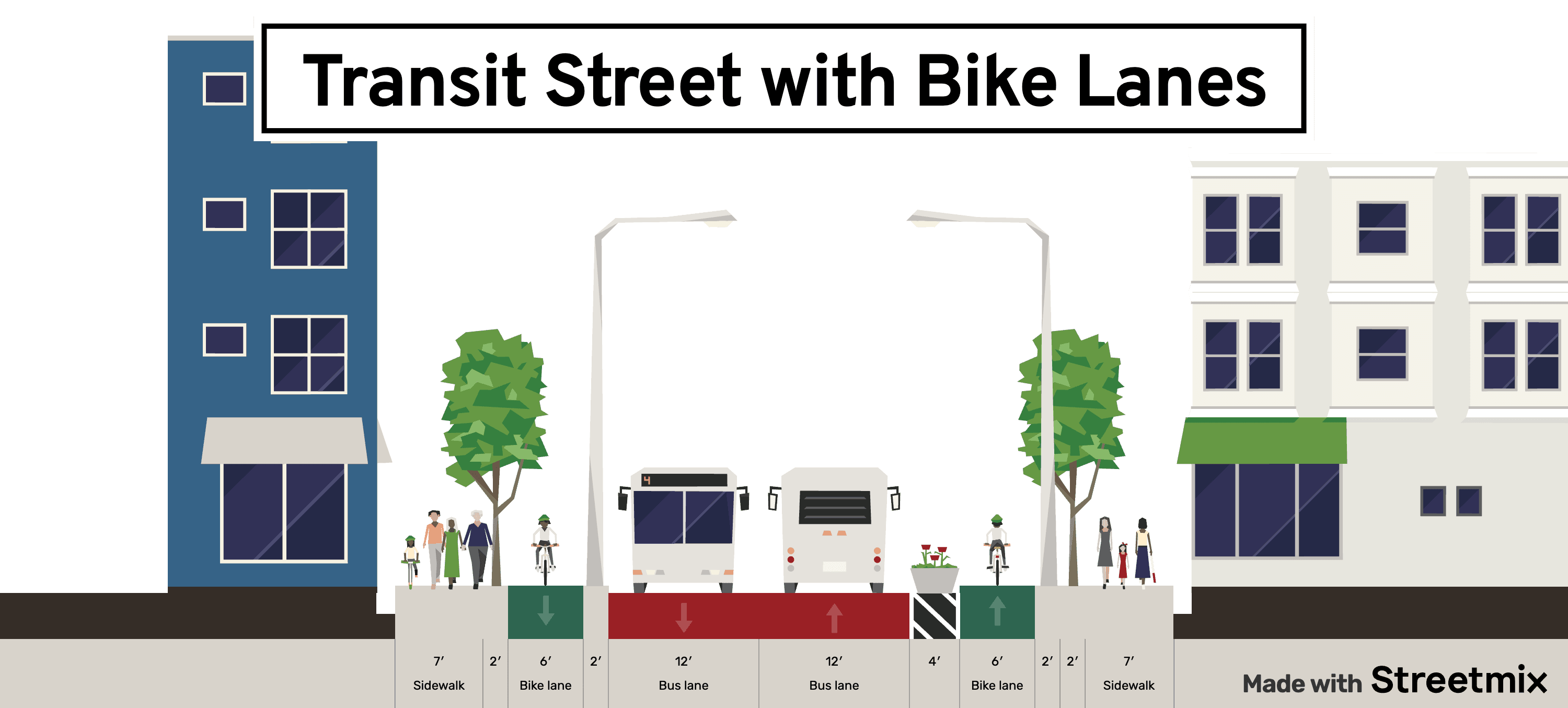
Transit street with wide bike lanes and room for wide sidewalks and other ameneties. Part of a suggested design for 5th and William in downtown Ann Arbor to allow high throughput of buses and bikes in downtown.
Check out this post
Transit Street Details
Configuration and details of a transit street in downtown Ann Arbor.
Learn MoreAnd "Hey Drivers!", that means you don't have to sit behind the bus downtown anymore either. Because it has its own dedicated space and you won't have to worry about it.
One benefit of transit-priority streets is that they provide incredible access for emergency services to move around the city without getting stuck behind traffic. Buses can easily pull over to the side of the road to allow emergency vehicles to pass, and the wide bike and pedestrian facilities make it easy for emergency vehicles to get through. This can help to reduce response times for emergency services, and to make downtown a safer place for everyone. Paris has already seen response times reduce by allowing emergency vehicles to use their wider bike lanes, since bikes can very easily get out of the way because of their size and maneuverability.
In addition to roadway changes, intersections would also prioritize transit in order to get them out of the city and to their destinations quickly. This may sound like it will cause more congestion for drivers, but it won't because modern smart traffic signals can prioritize buses and keep the flow of traffic moving by dynamically adjusting the signal timing based on the traffic conditions in real time. For example, if a bus is approaching an intersection, the signal can turn green for the bus and red for the other traffic, allowing the bus to move through the intersection quickly and efficiently. But it may only need to turn red for drivers for a few seconds because it is only a bus or several buses, and the signal can turn back to green for drivers as soon as the buses ar through, creating a much shorter red light cyle than a standard time-based traffic light.
Which Roads will be Transit Roads
The goal of the transit roads is to allow the rest of the transit newtwork to operate effictiently by not delaying buses in the downtown area where most of the traffic can tend to be. The transit roads will be the main north-south and east-west corridors through downtown allowing most bus routes to operate on these streets and connect to other routes at the transit center.
The North-South Transit Road will be 5th Avenue. This road is already a major bus corridor, and it connects the downtown area to the north side of town as a 1-way street towards Blake Transit Center. Blake is directly on 5th Avenue and, once the new development in the parking lot behind Blake is complete, it will have transit-only access directly off of and onto 5th Avenue accross from the Downtown Library.
5th Avenue also leads directly past the Ann Arbor Fire Department and Police Station, giving our emergency vehicles direct acess to the transit-only roads which have limited vehicles and therefore better resposne times for emergency vehicles. Think about it, professional bus drivers can far more easily be trained to give way to emergency vehicles than the average driver, and even a "very busy transit road" will have fewer vehicles than a "very busy car road" even though its carrying more people.
Additionally, 5th allows for connections to Kerrytown, the Amtrak Station, and across the river up Plymouth Road to the already existing transit priority corridor on Plymouth Road. This gives those transit vehicles excellent access to the downtown of the city.
Transit street with wide bike lanes and room for wide sidewalks and other ameneties. Part of a suggested design for 5th and William in downtown Ann Arbor to allow high throughput of buses and bikes in downtown.
The East-West Transit Road will be William Street. This road is already a major bus to access State Street and the Central Campus Transit Center via North University. It also has an existing bikeway on it and would be a great candidate for a transit and bike only road. like the one outlined above with 5th Avenue.
William also directly connects to Blake Transit Center and provides a direct route to Central Campus Transit Center, creating a direct connection between the two major transit hubs in the city. William also has a direct connection to to State Street which will become important as State Street has been rezoned as a TC-1 transit priority corridor. Having excellent transit access to downtown from State Street will be important for the success of that corridor.
The transit road will also extend beyond State Street to the Central Campus Transit Center by turning North on State street and East on North University to the Transit Center. This will allow for a direct connection between the two major transit hubs in the city. It also cuts State Street at the North University and William intersections, creating a pedestrian and bike only zone in the heart of where campus meets downtown and an already pedestrian dominated area and terrible place to drive. Let's just formalize the already existing conditions and make it a great place to walk, bike, and take transit.
Obviously, these two corridors also meet at Blake Transit Center at the corner of William and 5th, creating a major transit hub in the city where transit vehicles can get out of the downtown, regardless of traffic, and connect to the rest of their routes. University of Michigan vehicles would also likely be able to use North University from State to Washtenaw, allowing the University to maintain operations without adding siginficant private vehicles to North University.
Let's take a look at the #4 bus that goes from Blake Transit Center to Ypsilanti Transit Center primarily via Washtenaw Avenue. This bus will now be able to take William Street to State Street, and then North University to the Central Campus Transit Center. This will allow the bus to avoid the traffic on Washtenaw Avenue and get to the Transit Center quickly and reliably. From essentially Washtenaw Avenue and the Central Campus Transit Center, the #4 (and #104 express bus) can be on dedicated transit lanes all the way to Blake Transit Center for a quick and reliable trip.
This also helps server the already re-zoned TC-1 corridor on Washtenaw, and the major trip generators of the University of Michigan. MDOT has already released a plan for a portion of Washtenaw Ave to the East of US-23 to be redeveloped with a bus lane as the prefered option.
This corridor from Washtenaw Avenue to Blake Transit Center via North University and William is directly in line and helps us achieve the already voter-approved AAATA millage in 2022 to expand transit service in the city and specifically provide a BRT from Ypsilanti to Ann Arbor and from State Street near Briarwod North through Downtown to North Campus.
[Map of William Street Transit Road]
[Zoom in on State Street and North University]
[Zoom in on William Blake Transit Center]
[BRT and Transit corridors map]
Pededstrian Priority Areas
Pedestrian priority areas are areas of downtown that are designed to prioritize people walking, biking, rolling in a wheelchair, pushing a stroller, or riding a unicycle. These areas are designed to be safe, comfortable, and convenient for people to walk in, and to encourage people to walk to their destinations. They are also designed to be vibrant and welcoming places that people want to spend time in.
All over the world, the best places to visit and feel the vibrancy of a city are these pedestrian plazas; areas where its quite clear that the people are the priority, not the cars. Areas where markets and shows can be held, where people can sit and eat, where people can walk and talk without having to worry about cars or spend money. Especially for those living in downtown, this can be a great place to spend time and meet people. Think of the Diag on Central Campus, or the Downtown Streets we already shutdown for about 4 days every week from May to October.
Why not just make it permanent? Make it a place you can rely upon always being open for you to walk, bike, or roll through. A place with seating, fountains, trees, street performers, vendors, and more. A place you go to, not a place you drive through.
These pedestrian areas are proven to increase the economic vitality of the area, increase the safety of the area, and increase the vibrancy of the area. Even in Ann Arbor, the streets that are closed to cars for the Art Fair are some of the most vibrant and exciting places in the city, and the businesses also earn the most money. And this may seem strange that when you take away parking and vehicle access, businesses do better, but it's true. People are more likely to walk around and explore when they are on foot versus just driving through. And the one or two parking spaces directly in front of a business is certainly not enough to sustain the business just on people driving. Pedestrian areas create a high density of people walking around, and that's what businesses need to thrive in a downtown conext.
[Image of Ann Arbor's study about economic viability of pedestrian areas]
[Pedestrian example]
Specifications of Pedestrian Priority Areas
Pedestrian priority areas will be created by closing certain streets to vehicle traffic and opening them up to people walking, biking, and rolling. These areas will be designed to be safe, comfortable, and convenient for people to walk in, and to encourage people to walk to their destinations. They will also be designed to be vibrant and welcoming places that people want to spend time in.
This may not necessarily mean closing the street to all vehicles at all times. In fact, far from it. A street in a downtown city is an extremely valuable piece of land, as is any square foot in a downtown. So it must be used efficiently and effectively.
For example, we may not need to literally ban cars from particular streets. Instead, what's called a "modal filter" can be installed which will act as a barrier to cars but not to people walking, biking, or rolling. This can be done with bollards, planters, or other barriers that allow people to walk through but not cars. This can also be done with a "bus gate" which allows buses to pass through but not cars.
[image of modal filter]
When placed at the right intersections, these modal filters can create a network of pedestrian priority areas that are safe, comfortable, and convenient for people to walk in, and to encourage people to walk to their destinations without fully banning vehicle access. Its not a useful way to get through a city via car because you're blocked from continuing past a certain point, but if you're driving to a local destination, you can still get there via car and just turn around when you leave. For example, think of accessing an underground parking garage under an apartment or hotel, accessing a public parking garage, accessing a loading zone for a business, dropping off passengers from a taxi or ride share, or even a handicap parking space.
In addition to these modal filters, physical changes will help indicate to drivers that they are no longer the priority on this street an must drive extremely slowly such as 5mph. This can be done with raised crosswalks, textured pavement, and other physical changes that make it clear that people are the priority on this street, not cars. The raised crosswalk when entering a pedestrian priority area is a great way to slow cars down and make it clear that they are entering a different type of street. The textured pavement can also be used to indicate to drivers that they are entering a pedestrian priority area by giving slight physical and audio feedback. Bollards, planters and other physical barriers can also be used to narrow the street for vehicles, forcing the slow and cautious speeds.
Again, its not that you cannot access these areas via car, but that you must do so very slowly and carefully. You can take an Uber or Lyft directly to the front door of a business, but you must do the final few hundred feet and slow and cautious speeds. Deliveries can be made to businesses, but they must be done slowly and carefully or at specific times of day. Handicap parking can be accessed, for those who need it.
Some strets should be fully closed off, to any vehicle other than emergency vehicles. But those should probably have the mixed access described above so that people can still access the businesses and residences on those streets.
Pedestrian Priority Areas in Downtown
There are several areas that could be turned into pedestrian priority areas in downtown. These areas are already vibrant and walkable, and they are already popular with people who are looking to walk, bike, or roll to their destinations. By turning these areas into pedestrian priority areas, we can make them even more vibrant and walkable, and we can encourage even more people to walk, bike, or roll to their destinations. These are also areas that we already close to cars for events or during the summer during the walkable streets. This is only making these more permanent.
Main Street
Main Street is already a vibrant and walkable street, and it is already popular with people who are looking to walk, bike, or roll to their destinations. By turning Main Street into a pedestrian priority area, we can make it even more vibrant and walkable, and we can encourage even more people to walk, bike, or roll to their destinations. This is also a street that is already closed to cars for events and during the summer, so it would be a natural fit for a pedestrian priority area.
[Map of Main Street pedestrian priority area]
Liberty Street
Liberty Street is another vibrant and walkable street that is popular with people who are looking to walk, bike, or roll to their destinations. By turning Liberty Street into a pedestrian priority area, we can make it even more vibrant and walkable, and we can encourage even more people to walk, bike, or roll to their destinations. This is also a street that is already closed to cars for events and during the summer, so it would be a natural fit for a pedestrian priority area. It creates an East - West connection through downtown that is already popular with people walking and biking. Plus, its named Liberty Street, so it should be a place where people are free to walk, bike, and roll.
[Map of Liberty Street pedestrian priority area]
Detroit Street in Kerrytown
Detroit Street in Kerrytown is already a small 1-way brick road that gets very little traffic. By turning Detroit Street into a pedestrian priority area, we can make it even more vibrant and walkable especially for the days when the Farmers Market is open.
State Street
State Street will get multiple treatments and the specifics are more likely to be worked out in a final design than a generaly plan like this, but here's one suggestion.
From William to North University it would be transit-only as described above: 2 lanes of transit-only with wide spacing for stops, sidewalks, bike lanes, and cafe areas instead of parking.
South of William on State Street to South University could be a number of options. Since the intersection will be closed at William, that would act as a modal filter and likely limit vehicle traffic on this section of State Street siginficantly. Because of that, it may be possible to basically not touch this portion of State Street. Allow the street parking for direct access to campus, State Street businesses, and the Union and other buildings on the West side of the street. If it is parking and passenger drop-off only, there wil likely be very few vehicles on the street and it can be a very pedestrian and bus friendly area.
North of North University on State Street to Huron could be a combination of a pedestrian area and a drop-off area for that part of Downtown. This area is already a pedestrian area during the summer and for events, so it would be a natural fit for a pedestrian priority area. It also connects the pedestrian areas on Liberty and State Street.
Driving changes
Besides the transit and pedestrian priority areas, there will be some changes to the driving experience in downtown. These changes are meant to make it easier and safer for people to drive into and around downtown, and to make it easier for people to park in downtown.
Specifically, Division will be returned to a 2-way roadway and will provide connection access to Plymouth and Packard as a major North South corridor through downtown. This will help to reduce congestion on Main Street and State Street, and to provide a more direct route for people who are looking to drive into and around downtown. Its possible that the existing bike lane on Division could be fully removed in favor of the transit-only bike facilities just 1 block over on 5th Avenue. This could help make Division a car-specific road for North-South travel to pair with Huron being a car-specific road for East-West travel.
In addition to Division, other North - South corridors that will go all the way through downtown would include 4th Avenue, 1st, and Ashley. East - West corridors will include Huron, Packard, and Washington. Note that there are still many more lane miles for cars than for buses, bikes, or pedestrian areas.
How will this impact drivers?
If you're someone who frequently drives into downtown, you're likely screaming at your screen right now. "How will I get to my destination if I can't drive there?" "How will I get to my parking spot if I can't drive there?" "How will I get to my business if I can't drive there?"
The answer is that you can still drive to your destination, you can still drive to your parking spot, and you can still drive to your business. You just may not be able to drive there as quickly as you used to, and you may not be able to drive there as directly as you used to. But remember, this is only in the downtown area. Where land and space is at a premium and we must use it efficiently and effectively. Vehhicles take up a TON of space especially relative to how many people the move. Parking spaces take up space, are expensive to build and maintain, and do not generate the same revenue that an apartment or business would with the same land. Roadways take up space, are expensive to build and maintain, and do not generate the same revenue that a pedestrian area would with the same land. Think about how many small businesses could be supported by a pedestrian area versus a parking lot.
These changes will make it safer, easier, more reliable, and quicker to take public transit, bike or walk in and around downtown. Meaning far less cars from locals will be on the road competing with other drivers for parking and road space. This plan removes just X MILES OF ROAD FOR CARS and gives it to transit or pedestrians, that's just Y PERCENTAGE OF DOWNTOWN ROAD LANES. Additionally, these changes will make it easier to get dropped off in an Uber, have a delivery driver pick up food, or get inventory delivered to a local business because the streets will be less congested and more predictable.
The only way to reduce congestion is to make other options more attractive. If there are no reasonable alternatives to driving, then traffic will just keep getting worse and worse. But if the bus from Ypsilanti to Ann Arbor has mostly dedicated bus lanes and therefore runs on an extremely fast an predictable schedule, many more people will be willing to use it as reliable transit. And, let's say, it takes 30 minutes to get from Ypsilanti to Ann Arbor on the bus, but 45 minutes to drive and park. Many people will choose the bus? At what point does traffic get worse before you choose the bus? An option that saves you money from parking, gas, and insurance, and time from traffic and parking. Is the bus for everyone? No probably not, but it is for many people. People that just care about getting to their destination quickly, reliably and affordably.
Driver access to Downtown Parking garages
The specific streets selected for transit and pedestrian priority areas have been selected to minimize impact for access to parking garages, which will be used as the primary parking option for downtown. For more about parking reform, see the article on this site about parking reform. LINK LINK LINK
None of the parking garages will be inaccessible based on these transit or pedestrian areas. In fact, each will be easily accessible with limited conflict with transit or pedestrian areas so drivers can get to the garage quickkly without dealing with buses, bikes, or pedestrians.
4th & Washington garage
This garage is easily access from a major road of Huron which will not be blocked in any way. Main Street and 4th avenue (directly to the east and west of the garage to the North) will have no changes and will provide direct access to the garage.
4th and William garage
This garage will have easy access from the south and west via William, Main, and 4th Avenues. Again, William to the west of 4th (where the garage entrance is) will have no changes and will provide direct access to the garage. South of William, Main and 4th will also not have any changes providing access from Packard and Main Street to the South and East.
Library Lane garage
To be fair this is a somewhat difficult one to handle. It could be accessed relatively easily within this plan from Division via Library Lane, but having turning vehicles directly onto / off of Division is not ideal. If removing parking from Division, a turn lane for the Library Lane parking is possible. This does, however, leave the entrance on 5th Avenue.
The entrance on 5th could have a dedicated 1-way lane from Liberty into the entrance of the grage so drivers could turn south on 4th from Washington or Huron and stay in the far right (west) lane to go straight across Liberty and down into the garage.
Maynard Structure
This could be accessed most easily from the South via Thompson or Maynard from Packard, Division, etc. This gives great access to the pedestrian areas of Liberty and State Street with extremely short walks to those areas from the garage.
Others
The other garages and lots are esssentially not impacted by these changes at all. The Washington Lot and the 1st & Washington Garage are hardly impeeded at all, with unchanged access from Huron and Main with just a few turns.
The Ann & Ashley Garage is also not impacted at all, with direct access from Main Street and 1st Street as it always has.
The Thayer garage is slightly impacted as it can no longer be access from North University, but with access from Huron very close by, it should not be a significant issue.
Conclusion
Overall, this takes very few road miles away from vehicles and creates just a slightly more balanced infrastructure for our downtown that gives each mode at least some form of priority in specific areas. This is not a plan to eliminate cars from downtown, but to make it more balanced and equitable for all modes of transportation.
Drivers may have to make just a couple of extra turns, drive a little bit slower, and be a little more cautious when driving in downtown. But the benefits of these changes will be worth it. They will make it safer, easier, more reliable, and quicker to take public transit, bike or walk in and around downtown. They will make downtown a more vibrant and welcoming place that is accessible to all. They will help the City achieve its goals of reducing emissions, increasing safety, and promoting equity. And they will help the City achieve its goals of promoting a vibrant downtown that is accessible to all. Plus, when you park your car and get out, you'll be in a vibrant and exciting place that you'll want to spend time in.